Dunbarton is home to some of the best documented old cellar holes in New England. Join us on Saturday, September 19 at 10 a.m. for another hike to one of the historic Wonders of Dunbarton.
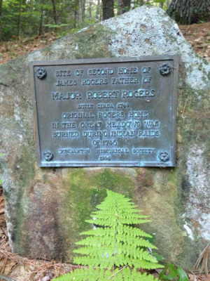
In 1739, Dunbarton's first white settlers, Joseph Putney and James Rogers, built log homes near the Great Meadows, moving their families here through the unbroken wilderness from Londonderry. Late one evening in 1746, the two families were warned of the approach of a marauding band of Indians and quickly gathered a few possessions and took flight to the garrison in Rumford (now Concord).
Putney and Rogers returned the next day to find their homes and barns burned, their cattle slaughtered, and all their apple trees cut down except for one. They and their families spent the next three years at the garrison in Rumford until it was safe for them to return to Dunbarton.
James Rogers was the father of the Major Robert Rogers, the famous leader of Rogers Rangers in the French and Indian War. We will tour the location of his second home site and also one of the most interesting old cellar holes in town, the Old Whipple Place in the Kimball Pond Conservation area.
Parking at the site location is limited, so we will meet at the Dunbarton Town Offices at 10 a.m. and car pool from there. The walk will total about 2 miles on flat ground and take about 2 hours.
For more information contact hike leader Margaret Watkins at margwatkins@juno.com.
Know anyone who might like to join us? Have them sign up for our email list and bring them along.